Fish and Fish Habitat
Island County Creek Restoration Planning
Fish species composition and distribution
Instream Habitat Reconnaissance
Fish species composition and distribution:
Juvenile coho salmon (Oncorhynchus kisutch), sculpin (Cottidae), and three-spine stickleback (Gasterosteus aculeatus) were observed in Maxwelton Creek; coastal cutthroat trout (O. mykiss and O. clarki) were found in both Maxwelton and Chapman Creeks. Non-native Largemouth bass (Micropterus salmoides) were observed in Chapman Creek. While no quantitative estimates of fish densities were performed, the number of cutthroat trout observed in Chapman Creek was unexpectedly low.
The Maxwelton watershed historically received outplants of juvenile coho and chum salmon from the Maxwelton Salmon Adventure and Salmon in the Classroom projects - outplants have not occurred since 2002. WDFW does not stock fish in either watershed. As is often the case, there are locations in both watersheds where man-made barriers to fish passage abbreviate the distribution of the fish in the watershed.
In addition to fish species composition and distribution, Washington Trout corrected mapping errors and updated the watertyping designations of both watersheds.
Maxwelton Creek Fish Observations

| All Species |

| Coho Observations |

| Cutthroat Observations |
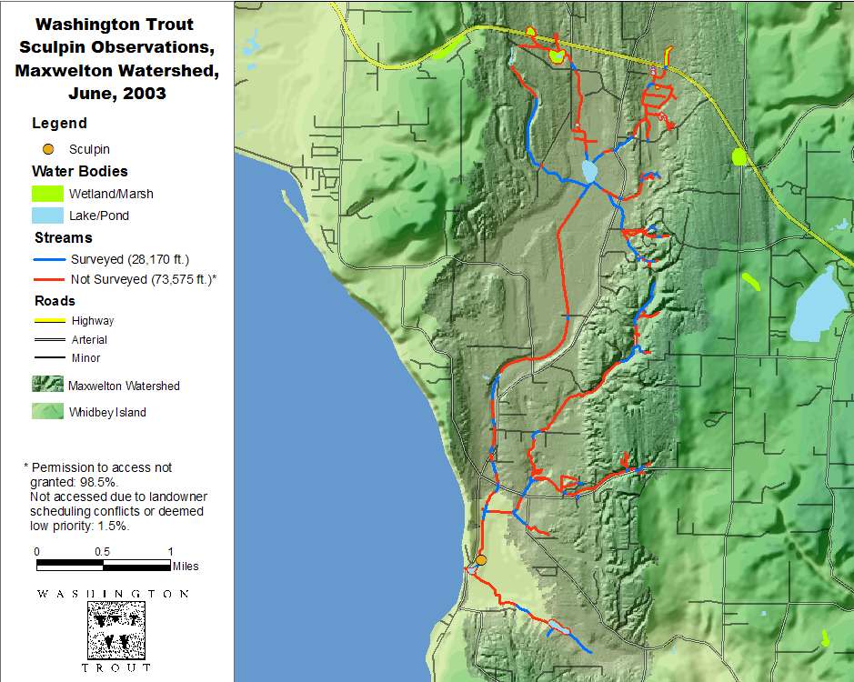
| Sculpin Observations |

| Stickleback Observations |
Chapman Creek Fish Observations

| All Species |
Water Typing
What is water typing?
In 1975, the Washington Department of Natural Resources developed the process of water typing to regulate forest practices that impact Washington’s surface waters, classifying streams into one of five types, depending on their physical, biological, and human-use characteristics (see table in Data Description).
Fish-bearing streams are classified as Types one, two, or three; Type-four and Type-five streams are non fish-bearing. Accurate water typing is essential to protecting fish and their habitats because the type and proximity of human activities allowable in areas adjacent to streams and other surface waters is dictated by water type. For example, riparian buffer zones required on type-two streams are greater than those required on type-four streams.
WDNR's original water typing efforts underestimated the actual miles of fish-bearing streams by almost 50% statewide. Hundreds of miles of wild salmon and trout habitat have been compromised because they were misidentified and subsequently subjected to inappropriate land practices. In 1997, WDNR revised its criteria for classifying streams as fish-bearing and upgraded protections for waters contemporarily identified as non fish-bearing. However, the ruling applied only to lands regulated for forest practices.
Under its Habitat Lost & Found program, WT has since 1994 been physically surveying streams throughout Washington to correct their misclassification and qualify them for the protection warranted under existing laws. We have upgraded the status of nearly 5000 stream reaches statewide.
Protecting Fish Habitats
Though originally designed for regulating forest practices, the WDNR water typing maps have been widely adopted by city and county agencies for regulating development activities outside the forest-practice zones. Unfortunately, the maps are even more inaccurate outside the forest-practice zones. Recent water-typing surveys by Washington Trout in rural and suburban landscapes in King, Snohomish, Jefferson, and Island counties documented similar error-rates in designating streams as fish-bearing or non fish-bearing, and provided evidence that a significant number of streams in these areas do not even appear on any maps. Of 38.4 stream miles surveyed by Washington Trout in King County during summer 2002, 17.7 miles or 46% were previously unrecorded on WDNR water-type maps.
Since 1997 WDNR has maintained a system for correcting water type designations in forestlands, but there is no comparable system to ensure timely updates in non-forestry areas subject to Growth Management Act (GMA) planning and regulations. Likewise, county and local planning and conservation ordinances rely on DNR water-type maps, often without adequate mechanisms for checking or correcting the data presented in the maps.
These factors are creating a crisis in how development along streams is being regulated. Local jurisdictions are relying on inaccurate water-typing maps to regulate land and water use, and many streams and the fish they support are facing threats from development and associated practices because they are not receiving protection they legally deserve.
Watertyping Methodology:
Upstream from anthropogenic barriers to fish migration and where fish absence surveys are inconclusive, physical parameters (stream width and gradient) are incorporated into the water Type designation in addition to fish presence. In the absence of fish upstream from an anthropogenic barrier, a stream reach that is greater than two feet wide and has no downstream reaches with gradients greater than 16% (upstream basin size <50 acres) or no downstream reaches with gradients greater than 20% (upstream drainage >50 acres) is considered Type 3.
A Smith/Root Model 12 backpack electrofisher was used in accordance with Timber, Fish, and Wildlife (TFW) electrofishing protocols. The electrofisher settings used were G-7 and 300 to 500 volts, depending on the conductivity of the water. All operators of electrofishing equipment had appropriate training, and held valid scientific collection permits issued by Washington Department of Fish and Wildlife (WDFW). Electrofishing was to be ceased in the vicinity of any observed chinook salmon, but no chinook were observed during the survey. No mortality of fish was observed while electrofishing.
Electrofishing teams consisted of two Washington Trout surveyors. The electrofisher operator surveyed in an upstream direction, while the field assistant followed immediately downstream from the operator to net any fish stunned by the electrofisher. Once fish presence was established, either through visual observation or electrofishing, the surveyors continued upstream until a change in instream habitat was encountered, above which electrofishing continued. The fish encountered were identified to species.
| Survey Summary: | ||
| Total Survey Length: | 20.5 mi. | |
| Upgrade Summary: | ||
| Total Upgrades: | 16.1 mi. | |
| Upgrade to Type 2: | 3.5 mi. | |
| Upgrade to Type 3: | 10.6 mi. | |
| Upgrade to Type 4: | 0.5 mi. | |
| Upgrade to Type 5: | 1.5 mi. | |
| Downgrade Summary: | ||
| Total Downgrades: | 225 ft. | |
| Downgrade to Type 3: | 225 ft. | |
| New Streams: | ||
| Total Previously Unmapped by WDNR: | 6.6 mi. | |
| # | Stream Name | Length of Pre-Survey Type 2 & 3 Streams (mi.) |
Length of Post-Survey Type 2 & 3 Streams (mi.) |
Total Upgrade for Watershed(mi.) |
| 1 | Maxwelton Cr. | 6.4 | 15.8 | 9.4 |
| 2 | Chapman Cr. | 1.3 | 2.5 | 1.2 |
Instream Habitat Reconnaissance
Washington Trout performed an instream habitat reconnaissance survey to document dominant habitat types existing stream conditions and currant land, riparian, and stream use patterns. A total of eight separate reaches were identified and surveyed in Maxwelton Creek and five reaches identified and surveyed in Chapman Creek. Surveys were only conducted on those properties where landowners had granted Washington Trout fieldcrews permission to access. Once reach break points were established, habitat reconnaissance surveys were conducted walking upstream on each of the reaches. A modified Timber, Fish and Wildlife (TFW) habitat unit classification system was used to characterize dominant habitat types on each parcel, augmented with additional habitat units typical of smaller or altered channels such as those found in Maxwelton and Chapman Creeks. A TFW habitat unit is defined as a variation in hydraulic conditions, such as velocity and water depth. Dominant habitat segments were assigned a unique identification number and placed in one of the following habitat unit classifications: (1) Riffle, (2) Riffle/Shallow pool, (3) Riffle/Pool, (4) Pool/Riffle, (5) Deep Glide, (6)Shallow Glide, (7)Pond, and (8) Dry Channel.
1) Riffle – a shallow, low gradient area with surface turbulence.
2) Riffle/Shallow Pool – sequential riffle and shallow pool portions of the creek throughout a segment. A shallow pool was defined as any pool with a residual depth between 0.3ft and <0.6ft.
3) Riffle/Pools – sequential riffle and pool portions of the creek throughout a segment with more riffle length than pool length. A pool was defined as impounded water within a closed topographical depression with a residual depth > 0.6ft.
4) Pool/Riffle - sequential pool and riffle portions of the creek throughout a segment, with more pool length than riffle length.
5) Deep Glide – deeper area >0.6 ft in depth without surface turbulence and a uniform channel bottom.
6) Shallow Glide – shallow area <0.6 ft in depth without surface turbulence and a uniform channel bottom.
7) Pond – impounded water, either natural or anthropogenic.
8) Dry channel – no surface water
Dominant habitat units on individual parcels were identified and documented sequentially walking upstream. Occasionally a parcel had more than one distinctly dominant habitat type. In this case more than one habitat type was assigned to the same parcel number. Wood and Spawning gravels were given a qualitative quantity rating of (N) none, (S) sparse, (M) moderate and (A) abundant.
Washington Trout made Riparian and Land Use characterizations using TFW Land Use and Riparian Serial Stage classifications. The TFW Land Use descriptions were modified to include a category (9) for “fallow field”. Thus, a designation of 9/63 means that the dominant land use is fallow field (9) with a RBZ (6) dominated by timber (3). A visual estimate of stream cover was recorded for each parcel, densiometers were not used. Invasive or monotypic species, beaver dam activity, mass wasting, cattle access, armoring, flood prone potential, and irrigation withdrawal activities were recorded with as “yes” if present and “no” if absent.
|
| Maxwelton Habitat Reconnaissance Matrix |
|
| Chapman Habitat Reconnaissance Matrix |
Spawning Surveys:
Surveys of the numbers and species of fish that spawn in a stream are a useful index of that stream’s productive capacity and health. Spawning, carcass, and redd surveys also provide data that facilitate the identification and prioritization of habitat rehabilitation projects by revealing factors like migration barriers and a lack of spawning gravel that may limit production within watersheds.
Salmon spawning surveys were conducted weekly between October and December 2003. Surveys were performed by Washington Trout on index reaches that had characteristics favorable to salmon spawning, and were located on parcels where crews had been granted permission to access. The spawning survey index reaches were identified based on the characteristics (flow, substrate, channel morphology) observed during the habitat reconnaissance. Additional data regarding cutthroat and rainbow trout redd observations were collected during the fish passage inventory performed during spring 2004.
Chapman Creek:
No adult salmon were observed in Chapman Creek, not surprising given the small amount of spawning habitat that is currently accessible to salmon because of the barrier culvert located under West Camano Drive 1380ft upstream from the creek’s mouth.
Maxwelton Creek:
- One live male coho was observed on Parcel# R32933-052-0810 on October 23, 2003
- Four or five chum heads and four chum carcasses without heads were located at the Maxwelton Outdoor Classroom on November 25th (the carcasses were filleted and believed to be from a different stream origin).
- One coho carcass was found on Parcel# R32933-323-1000 on November 25th.
- Two salmonid remnants (unknown species) were found on Parcel# R32804-412-0310 property on December 2, 2003.
- A total of 10 redds was observed in the reach extending from the Outdoor Classroom to Parcel# R32933-323-1000; no other redds were observed in Maxwelton Creek or its tributaries during the salmon spawning surveys.
As is often the case, there are locations in both watersheds where man-made barriers to fish passage abbreviate the distribution of the fish in the watershed.